Unlocking the Mysteries of Earthquakes and Deep Ocean
Prof. Hongfeng Yang
Earth System Science Programme, Faculty of Science
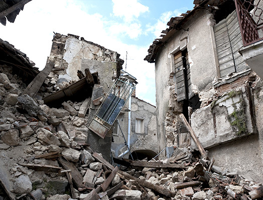
Earthquakes may cause significant damage and casualties, and sometimes even devastating tsunamis, as vividly illustrated by the 2004 Sumatra and the 2011 northeast Japan quakes. To reduce losses from earthquakes demands a fundamental understanding of the physics of this natural hazard.
Why do earthquakes occur? The first reason is because the Earth is too hot. Earthquakes represent energy release from the interior of the Earth, where a huge amount of heat is stored and slowly transferred to the surface. The second reason is that the outer shell of the Earth is divided into a few rigid blocks, termed tectonic plates, which move relatively to each other along the plate boundaries. In the long term, tectonic plates move in an average rate of a few centimetres per year, which is about the rate our fingernails grow. However, the movement during earthquakes can accelerate to a matter of metres per second.
Why do the movements between plates sometimes become so rapid as to produce earthquakes? It is because parts of a plate may not move as fast as other parts do, or may not even move at all. Consequently, the friction or resistance of movement along the plate boundary is quite non-uniform. For those that move slower or do not move, there is a deficit in distance (slip deficit) on the contact interface. In a whole rigid plate, the parts with slip deficits will eventually catch up on the distance, in a much shorter time and thus at a faster rate. This is why earthquakes occur on plate boundaries and repeat at certain time intervals.
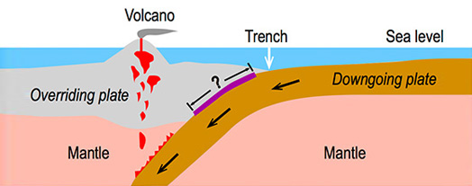
The rate of plate movements can be measured by GPS. After careful measurement and meticulous calculations, scientists can estimate the degree of locking, a term used to represent how much motion is occurring on the parts with slip deficit (1 denotes fully locked). If we observe a plate boundary with the degree of locking close to 1, there is no doubt that earthquakes will occur in the future. Such locking analysis is commonly used in subduction zones, the convergent plate boundary where oceanic plates with more weight descend beneath the less dense continental plates (Figure 1). Subduction zones are also where the largest earthquakes occur, some of which may trigger high tsunami waves.
Can we predict the magnitude of the next earthquake? It is very challenging but that is what our earthquake seismology group at CUHK is presently working on. To arrive at a reasonably good prediction of the size of future earthquakes requires accurate locking distribution, a good understanding of the frictional properties of rocks, and intensive numerical computation. At present we are working on the Nicoya Peninsula, Costa Rica, in the Central American subduction zone. This site was chosen not only because the locking distribution at Nicoya is one of the best in the world, but also because an earthquake of magnitude 7.6 took place there in 2012, allowing us to systematically validate our model predictions. The results are quite promising in that we can successfully estimate the size of future earthquakes from locking distribution, although the precise time of the next earthquake remains unknown.
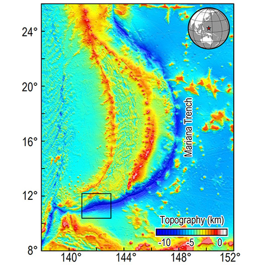
Compared to the Nicoya Peninsula, many of the other subduction zones around the world do not have well constrained locking distribution and are much less understood, partly because they are in deep waters. The Mariana subduction zone is such an example (Figure 2), where no locking distribution is available because of its remoteness from the continent and the lack of sufficient GPS measurements. Although earthquakes with magnitudes of 6 or greater are not absent, the Mariana subduction zone is an ‘aseismic’ end member because of the limit on the length of seismogenic zone. Without near-field observations, however, we cannot know much details on the shallow seismogenic zone at Mariana and thus can not scrutinize what made scientists call Mariana ‘aseismic’.
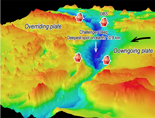
In 2017, a scientific expedition led by the author and collaborators from the South China Sea Institute of Oceanology will be conducted in the Marianas. The primary goal of this expedition is to deploy the Ocean Bottom Seismograph (Figure 3), an instrument that measures ground movements, for the first time near the Challenger Deep, the deepest spot on Earth (10.9 km). Using data recorded by such instruments, we hope to clearly delineate the shallow seismogenic zone in southern Mariana. There will be difficulties and surprises waiting for us, but exploring the unknown is one of the driving forces of scientific research.